Grow With The Flow
These iconic waterways offer a study in history, art and science.
By Laurie Fickman
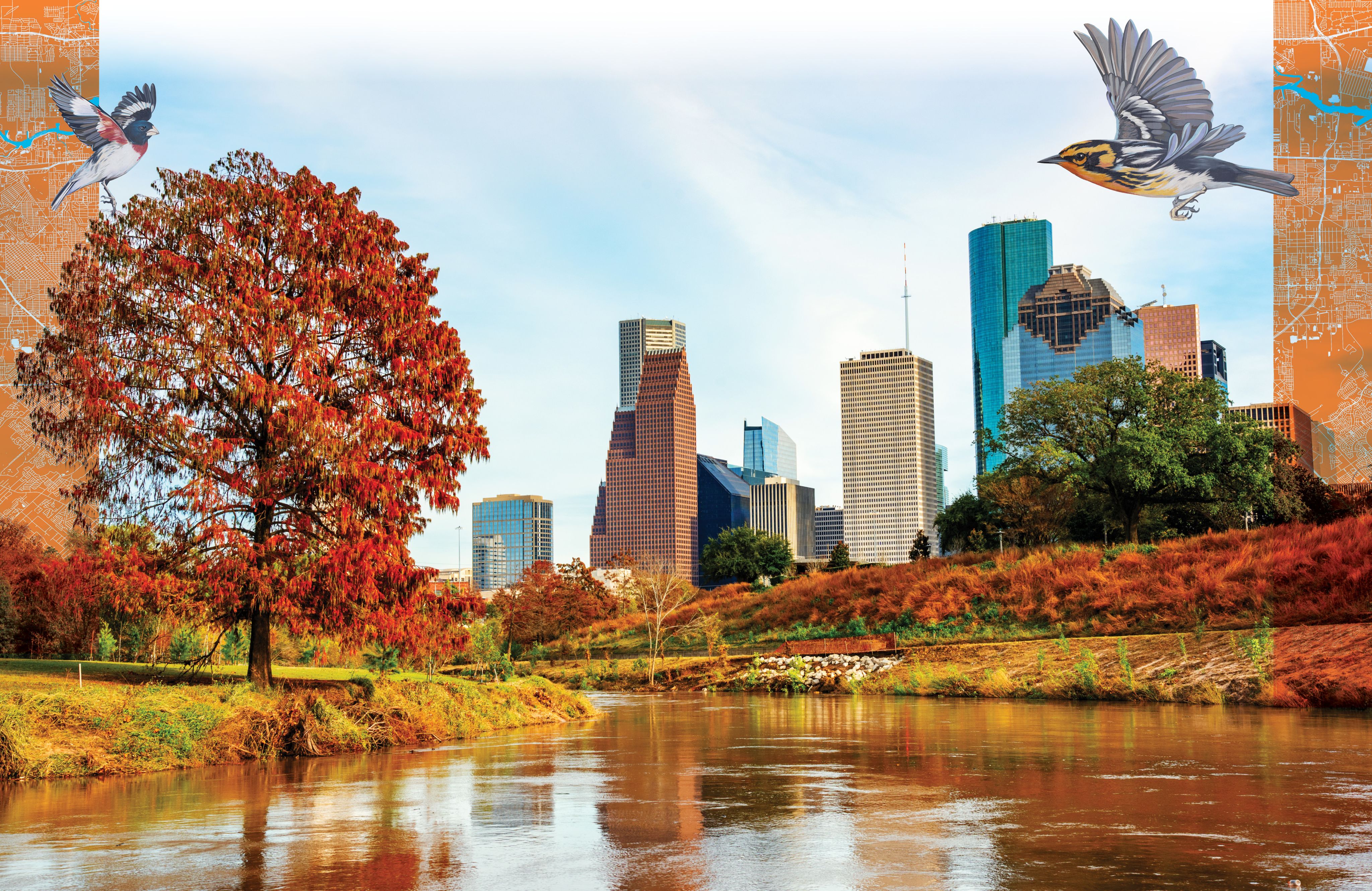

Perhaps the unsung heroes of Houston, its bayous have been shaping the city for hundreds, even thousands of years. Critically important to Houston’s economic success, the bayous have become vibrant canvases for public art, outdoor classrooms for conducting ground-breaking research and natural spaces for outdoor activities. Houston's bayous are not just swampy water—they're the lifeblood, the canvas, the green oasis and the laboratory of this incredible city.


Photo by Geoff Lyon/Courtesy of Buffalo Bayou Partnership
Photo by Geoff Lyon/Courtesy of Buffalo Bayou Partnership
OH, GIVE ME A HOME ...
The oldest of the Houston’s four major bayous, Buffalo Bayou was formed 18,000 years ago and was home to the indigenous Akokisas and Karankawa peoples. Lifetimes later, Houston’s bayous would become vital pieces of the city’s drainage and water systems and catapult the town to become an influential trade center. The contributions of the county’s 23 watersheds feeding into the area’s major bayou waterways were so important that Houston would take on the moniker, “Bayou City.”
Little doubt exists that buffalo once roamed over the aptly named Buffalo Bayou. In fact, fossils found close to Armand Bayou point to bison in the area 35,000 years ago.
But the history of Houston’s bayous doesn’t begin and end with a species stampede. Diaries from Spanish explorer Cabeza de Vaca in 1535 note the lifestyle of Native Americans along the bayou banks, where they crafted dugout canoes, fished and formed villages.
That was eons before the bayou’s wartime historical significance became etched in state history. The point where it merges with the San Jacinto River was the famous site of the final battle for Texas Independence, the Battle of San Jacinto in 1836. Yes, Buffalo Bayou is the site where Sam Houston and his army of 900 Texans defeated General Antonio López de Santa Anna and his Mexican army of 1,300 men.
In case you wondered, in Texas that’s what’s called an historical mic drop.
BUILDING A CITY ON SWAMPY BAYOU LAND
Later that year, two brothers, John and Augustus Allen, founded the city itself at the confluence of Buffalo and White Oak Bayous, a spot to be forever known as Allen’s Landing, the birthplace of Houston. Maybe they were visionaries, or maybe just braggarts, but they envisioned—and touted—a world-class city and enticed people to join them, distributing flyers portraying Houston, with its accessible bayous, as a mercantile center of transport and commerce.
It wasn’t. At least not yet.


Vintage photo of a view across the waters of Buffalo Bayou at the Port of Houston.
Vintage photo of a view across the waters of Buffalo Bayou at the Port of Houston.
“The bayou was nowhere near navigable to big ships at that point,” says Debbie Harwell, instructional assistant professor of history at the University of Houston College of Liberal Arts and Social Sciences and the Honors College. “But what’s interesting is that everything they put in the ad, which was false at the time, comes to pass. Not because the Allen brothers did it, but because they had the vision of what Houston could be and the civic leaders who followed really made it happen.”
As advertised, Buffalo Bayou played a key role in the city’s success, eventually becoming the economic backbone of the region’s economy, in the form of the Houston Ship Channel and Port Houston. The original port was downtown at Main Street where the bridge crosses at Allen’s Landing and later, the University of Houston-Downtown.
“You don’t want your port in the middle of a growing downtown, so they had to dredge the bayou to make it deeper and wider, and in 1914 it was opened as a deep-water port a few miles east of downtown,” Harwell says.
Today, Port Houston is one of the busiest seaports in the world. And as historians often sum up: “Houston is the town that built a port that built a city.”
Of course, historians in the know add that it all started with the bayous.
BEAUTY ON THE BAYOUS
Imagine the glee in the eyes of the prophetic Allen brothers if they knew the 10-mile stretch of Buffalo Bayou from Shepherd Drive to the Port of Houston Turning Basin became a veritable outdoor art exhibit, housing world-class permanent and temporary works of art. Among the permanent fixtures is a piece by the design and art firm TTWEAK etched into the wharf at Allen’s Landing commemorating the site and the goods that were traded there—from molasses to hemp rope.


The TTWEAK permanent art fixture located at Allen's Landing is etched into the wharf to commemorate goods traded in the past.
The TTWEAK permanent art fixture located at Allen's Landing is etched into the wharf to commemorate goods traded in the past.
Fittingly titled, "Confluence," a 223-foot-long mural on the retaining wall at the confluence of White Oak and Buffalo Bayous, is a tribute to the bayous themselves, with images of six bird species floating above Houston’s bayou system.


Confluence mural
Confluence mural
As benefactor Laura Bacon describes it, “This mural is about celebrating Bayou Greenways and discovering Houston’s amazing position in the center of North America’s largest migratory flyway. One day, Houston will be known as the only major city in America where you can eat at an award-winning restaurant on Saturday night, stay in a wonderful hotel, and see 128 species of birds before noon on the following morning.”
More Houston art magic was unearthed at The Buffalo Bayou Park Cistern. An underground, former water reservoir in Buffalo Bayou Park, this once-hidden gem is open for history and art tours.


The Buffalo Bayou Park Cistern is open to the public for historical tours as well as art tours. Photo by Katya Horner/Courtesy of Buffalo Bayou Partnership
The Buffalo Bayou Park Cistern is open to the public for historical tours as well as art tours. Photo by Katya Horner/Courtesy of Buffalo Bayou Partnership


Tolerance, by internationally recognized Spanish artist Jaume Plensa, is a group of seven sculptures placed in 2011 alongside the construction of the Rosemont Bridge.
Tolerance, by internationally recognized Spanish artist Jaume Plensa, is a group of seven sculptures placed in 2011 alongside the construction of the Rosemont Bridge.


The Buffalo Bayou Park Cistern features concerts, including the popular Underground Sounds series. Photo by Lawrence Elizabeth Knox/Courtesy of Buffalo Bayou Partnership
The Buffalo Bayou Park Cistern features concerts, including the popular Underground Sounds series. Photo by Lawrence Elizabeth Knox/Courtesy of Buffalo Bayou Partnership


Photo by SWA Group, Jonnu Singleton/Courtesy of Buffalo Bayou Partnership
Photo by SWA Group, Jonnu Singleton/Courtesy of Buffalo Bayou Partnership
BAYOUS AS ENVIRONMENTAL RESEARCH CENTERS
At various times, the bayous also serve as the perfect petri dish for earth and atmospheric scientists, environmental researchers and many other research departments at UH.
Case in point: Hurricane Harvey, the largest rainfall event in U.S. history that caused massive flooding in Houston in 2017, also served to underscore why Houston’s bayous and waterways are still educationally relevant and a valuable tool to help predict Houston’s geological future.
A post-Harvey research team, in the lab of Julia Wellner, associate professor of geology, used lidar, or light detection and ranging, a remote sensing technology that measures the elevation of the ground surface, to determine the elevation change from pre- storm to post-storm due to sediment movement. The team uncovered numbers and comparisons that seem staggering. Twenty-seven million cubic meters of sediment, or 16 Astrodomes, moved through 12 Houston waterways and Addicks and Barker reservoirs during the nightmare that was Harvey, decreasing holding capacities in the reservoirs by about 1.2% and 1.6%, respectively.


Buffalo Bayou during the aftermath of Hurricane Harvey in August 2017
Buffalo Bayou during the aftermath of Hurricane Harvey in August 2017
After the storm, up to five feet of sediment accumulated in the Houston Ship Channel. It cost $350 million to dredge the channel back to its pre-Harvey depth. From August 25 to 31 of 2017, the study found the amount of sediment moved through Houston was equivalent to about 40% of the sediment discharged annually to the Gulf of Mexico by the Mississippi River. Worse yet, researchers concluded, the enormous amount of sediment, or sand and mud, that flowed through Houston waterways during Hurricane Harvey could seriously impact future flooding events and be costly to the city of Houston.
The team doesn’t place full blame on the hurricane. Researchers correlate modifications made by humans to bayous, rivers and streams over the past century, with empowering Harvey to do its worst.
Also, shortly after Hurricane Harvey ravaged Houston, members of Hanadi Rafai’s environmental engineering lab collected water samples from 41 bayou sites for 90 days. They found the flooding transported as much as 1,000 kg of chromium and 650 kg of nickel into Galveston Bay and caused a drop in the pH of the region’s waters.
“Bayous are an open and limitless laboratory for exploring and understanding our natural and built environments,” says Rifai, Moores Professor and director of the Hurricane Resilience Research Institute. Rifai says she uses the bayous “as often as possible recreationally and quite often for research.”
BLAMING THE BAYOUS
Still, with all their rich history and ability to serve as living classrooms, Houston bayous often get a bad rap. They quickly overflow in rainfall and, as Harvey history shows, send torrents of water through the streets during hurricanes.
Efforts like Project Brays, a $480 million plan of action that reduces flooding risks in the Brays Bayou watershed, are underway. Project Brays is the largest flood damage reduction program ever undertaken by the Harris County Flood Control District.
“We have developed faster than our infrastructure can keep up. But don’t blame the bayous, they were here first!” says Harwell.
Perhaps it’s no coincidence that in Houston, a city marked by its entrepreneurial drive, even its natural landscapes have been harnessed for growth.

Let’s Get Something Straight...
By Rebeca Hawley
River straightening, a type of artificial stream modification, is an engineering technique used to shorten the distance to the ocean and increase water flow, which reduces flooding in surrounding areas.
The technique was used on Houston’s waterways in the 1940s and ‘50s. Straightening can be as minor as removing bank vegetation or as extreme as replacing the banks and channel floor with concrete. While it paved the way for urban development in Houston, a recent University of Houston study found more sediment now moves downstream as a result.
Andrew Stearns, first and corresponding author of the 2023 sediment routing study published in "Geology," found a notable correlation between stream modification and sediment bypass. The study was conducted while Stearns was earning his master’s degree in the laboratory of Julia Wellner, associate professor at UH’s College of Natural Sciences and Mathematics.
“Our study provides policymakers with vital information for sediment management in urban watersheds. Not much attention has been given to sediment management, but it has big implications for the city itself, and can be quite costly when omitted from a watershed plan,” Sterns explains.
Sediment deposits left in the wake of Hurricane Harvey reduced holding capacities in Addicks and Barker reser- voirs by more than 1%.
“If Harvey were to happen again today, there would be less room for water in Addicks and Barker reservoirs because of the sediment that got left behind from Harvey,” Wellner says. “That’s the significance—sediment takes up space no longer available for water.”
Stearns cites Lake Houston as an example. A large sand bar recently emerged from the water where the west fork of the San Jacinto River enters the lake near Kingwood. The U.S. Army Corps of Engineers has dredged the top of the bar several times in recent years.
“If you have this big mound of sediment blocking water flow to the lake, there’s less area for the water to go,” he says. “During floods, the water goes around that bar of sediment, and into somebody’s house.”
CAUSES OF MASSIVE SEDIMENT MOVEMENT
The research team utilized lidar technology and ground observations to study elevation changes due to sediment shifts. Stearns says there was so much sediment in the waterways due to compounding factors of the deluge of rain and human modifications to the surrounding environment.
“We found 75% of Houston received over three feet of rain in five days,” he says. “When you get nearly your annual rainfall in such a short amount of time, that’s going to move large amounts of sediment quickly.”
Whether humans created or contributed to more sediment, Stearns and Wellner say it is likely. Because urban sprawl has covered prairie and natural green spaces with impermeable concrete, more water flows into drains and eventually to surrounding bayous. And with more developed land, erosion rates are higher as well, which contributes to the sediment.
“With more rainfall, more runoff and more erosion, you are moving more sediment through bayous and rivers,” Stearns explains.
INFORMATION FOR POLICYMAKERS ON A BUDDING RESEARCH TOPIC
The team hopes their study leads researchers and policymakers to collect data on regional sediment movement on a regular basis, not only because of how costly it is to dredge sediment out of waterways, as seen in the ship channel, but also because of the potential impact it can have on flooding in the Houston area. Additionally, they want policymakers to see the impact river straightening can have on sediment movement.
Shuhab Khan, professor of geology at UH, and Jerome Kendall of the University of New Mexico are contributing authors of the study.


